The Light Horse Interchange, where the M7 meets the M2 in Sydney’s west.

Noise walls on the M7.

The surrounding parkland is visible through transparent noise screens on the Hoxton Park viaduct.

The 450-metre, clear span bridge at Old Windsor Road.

Light Horse Interchange.

Internal view of a shared path bridge over a local road. Four shared path bridges cross the M7.

The 40-kilometre shared Westlink Cycleway and Walking Path runs through the open space associated with the M7.

The shared path bridge crossing the M7 at Cecil Hills.

Quakers Road bridge over the M7, an example of the coloured blade walls, which clad the piers of a number of bridges.

Part of the artwork at the Light Horse Interchange, which represents a parade of the light horsemen of the First World War. Wire plumage mimics the distinctive emu feathers worn in the slouch hats of the diggers.

Illuminated pyramid marker at the southern end of the M7, where it intersects with the M5.
Since the early twentieth century, highways have been a significant part of city and country landscapes. If the city is the heart of a region, its highways have been the dominant (overly so, some may argue) arteries that fed the city and distributed its products. They have occupied the minds of planners and engineers and become major elements in the urban landscape, connecting at a macro scale and often severing at the micro.
Highways don’t present opportunities for conventional urban form or space. Not here the parvis before the cathedral or the park defined by suburban development. This is space uncontained by the density of built form, and it is that lack of containment that gives expression to the sculptural elements of large-scale engineering, which, at their best, are the pure expression of structure.
In 1966 Lawrence Halprin wrote, “When freeways have failed, it has been because their designers have ignored their form-giving potentials and their inherent qualities as works of art in the city. They have been thought of only as traffic carriers but, in fact, they are a new form of urban sculpture for motion. To fulfil this aim freeways must be designed by people with sensitivity to structure but also to the environment; to the effect of freeways on the form of the city; and to the choreography of motion.” 1
More recently there has been a preoccupation with moving beyond structural expression and its refinement and dealing with elements that accrue to highways in their urban setting, or making bold gestures at place making or place marking; City Link Gateway in Melbourne and Craigieburn Bypass being excellent examples.
In December 2005 the much-anticipated and somewhat delayed Sydney Metropolitan Strategy was released. In the same month, the M7 toll motorway was opened ahead of schedule. Road infrastructure, with its attendant federal seed funding, has been steaming ahead of other transport infrastructure (and strategic planning) in Sydney for some time. The M7 features prominently in the metro strategy as part of the primary road transport matrix across the city. It serves as a major connector to the newly proposed growth areas in the north-west and south-west sectors of the city.
The M7 arcs for 40 kilometres around Sydney’s suburban fringe and, barring the Lane Cove Tunnel, completes the Sydney Orbital – a giant motorway ringing the bulk of Sydney’s urban development and linking the M2 in the north with the M5 in the south. It provides a bypass to Sydney as part of the inter-capital route system and includes a 40-kilometre grade-separated shared path with its own bridges and lighting.
Deemed a success in engineering and transport terms, the M7 has won major engineering awards, was finished ahead of schedule, and has received none of the negative press that has marked other recent major road developments in Sydney: the M5 East – poorly sized; the M2 – poorly detailed; and the Cross City Tunnel – poorly priced and marketed.
So what worked on the M7? It was, after all, procured through a Public Private Partnership process, which is generally perceived to sacrifice quality for time and cost. But here we have a roadway made of simple, well-designed and executed elements in a consistent language for its entire 40-kilometre length.
Its success starts with the brief. Design was integrated in the bid and urban design was specified alongside engineering, management and legal requirements. The Roads and Traffic Authority (RTA) set up an urban design evaluation team under their senior urban designer, Raeburn Chapman, to assess the urban design in the proposals, and this in turn became the RTA’s design monitoring and advisory panel for the project. Design became a serious pursuit and was embraced by the entire team, requiring commitment from the proponent and their engineers as well as their urban design and landscape team, Conybeare Morrison and Context.
The highway layout is the primary ordering device for the urban elements that populate it. The road passes through essentially flat urban and rural settings, and alongside Western Sydney Parklands for 27 kilometres of its length. The alignment has been carefully planned to maximize opportunities for views as well as creating smooth grades for safe motoring, but, in an even topography, there are few opportunities for the surprise vista at a turn in the road or a landscape glimpse revealed from the crest of a hill. Views are captured through long intermittent panels of glass noise walls.
Other sections of road – so successful in connecting motorists from one part of Sydney to another – effectively disconnect users from the surrounding suburbs.
Here, in place of landscape features, a suite of urban elements and artworks mark occasions along the journey. Refined structures provide a backdrop to this mass transit corridor and to the kinetic energy of the vehicle. Noise walls, toll gantries, lighting and signage are of a consistently high quality. The bridges bisecting the highway have clean, simple spans – the piers, clad in colourful blades extending beyond the deck, make a platform for the light poles. The clear soffit, the continuous parapet, the slightly sloping throw screens, and the neatly resolved abutments provide a calm and elegant series of structures, adding to the quality of the journey.
These elements collectively demonstrate a commitment to design and to a healthy collaboration between engineer and urban designer – the 450-metre-long haunched road bridge crossing Old Windsor Road being the most spectacular example.
The lighter, shared bridges across the road corridor are less successful. Simple silver triangular trusses are topped with a complicated canopy of meshed screens. The screens’ geometry varies and dilutes the strength of the structural form supporting it. The overall impression is one of mismatched elements: either the truss seems too heavy or the throw screen too light and playful.
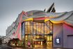
At its north end, the M7 morphs into the M2, but the other two major intersections (the M4 and M5) are marked with the necessary flyovers and exit ramps, but also with major art installations. The M4/M7 14-hectare interchange is dramatic, super-scaled and surprisingly elegant. The geometry of the post-tensioned box girders, the simplicity of the piers and the slenderness of the sweeping curves of the feeder ramps add a lightness that belies their engineering achievement.
Named the Light Horse Interchange, the intersection commemorates the regiments that served in World War One. The centrepiece of the installation is a 55-metre light pole and ranked along the four medians that approach it are markers representing soldiers on parade. These are coloured the red of Flanders poppies, and wires bunched at their crown symbolise the distinctive emu feathers worn by the light horsemen in their slouch hats.
This is a strong theme for public art, but its execution is disappointing. It is artwork seen in passing, at speed, and calls for a robust scale so that the rhythm of the parade is legible. The feathers, too, are unconvincing.
The intersection with the M5 in the south is marked with a 25-metre pyramid of earth from the excavations. Here, the scale is right but the shaping of the hill is too crude and the geometry imperfect, so that its giant steel cap sits uncomfortably, effective only as a night beacon. The night image of the road corridor is, however, a great success, with the major elements well lit to celebrate scale and sculptural form.
The landscape design is a unifying element establishing a character based on indigenous vegetation communities. Colour in the planting is used to highlight and reinforce the colour of the structures, which are drawn from local references.
Sadly, the landscape philosophy is not yet fully evident. The recent drought has caused about 30 percent failure of the planting so far and the substantial planting programme has been held back, awaiting more conducive weather conditions.
The M7 team has achieved a high-quality outcome, sensitive to its sculptural form, to its structure, to its place in the city and to its local environment. The success comes from the integration of the skills of the urban and landscape designers with those of the road and bridge engineers. Perhaps the ensemble would have had greater success with the inclusion of a public artist.
Images: Brett Boardman
1. Lawrence Halprin, Freeways (Reinhold Publishing Corporation, New York, 1966).
Credits
- Project
- Westlink M7
- Urban design
- Conybeare Morrison International
East Sydney, Sydney, NSW, Australia
- Project Team
- Darrel Conybeare, Colin Polwarth, Oi Choong, Julia Finlayson
- Consultants
-
Acoustic design
Heggies Australia
Design and construct Abigroup / Leighton Joint Venture (ALJV)
Engineer Maunsell / SMEC Joint Venture (DJV)
Landscape design Context
Lighting design Webb Australia Group
Tolling Transurban Group
Traffic consultant United KG [formerly Alstom]
- Site Details
-
Location
Sydney,
NSW,
Australia
- Project Details
-
Status
Built
Category Landscape / urban
Type Public / civic
- Client
-
Client name
Roads and Traffic Authority NSW (RTA)